Hi all,
Actualy the DEM data with world coverage is limited, low quality.
To find good quality (high definition) DEM data we need to go country by
country DEM, I meant, every country seems to have his own good quality DEM.
The only good DEM data with world coverage is just for military purposes, so
far. May be in the future we can enjoy world DEM high quality data.
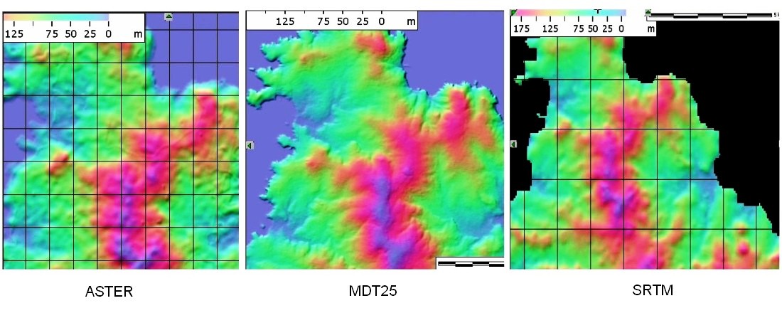
Check the comparation between STRM, ASTER and MDT25;
http://www.ea1ddo.es/dem/Comp.jpg
You can see that SRTM world data is low resolution. ASTER is a little bit
better but has low resolution in heights. The you can see the high resolution
from the MDT25 with sharp countours and noce hills definition.
Spanish DEM info;
http://www.ea1ddo.es/dem/dem.html
73, Maximo - EA1DDO & HK1H
> Date: Sat, 20 Aug 2011 08:00:10 -0400
> From: fhdez@vpnet.net
> To: n6bv@arrl.net; towertalk@contesting.com
> Subject: Re: [TowerTalk] Terrain data for HFTA
>
> Dean,
>
> Me too would like to take that data from google. In my case ive found
> that the data
> from SRTM is never true to my terrain. I trust google earth because it
> gives me the
> exact contour and height.
>
> For me extracting from google was a little painful but rewarding, after
> i remodeled the terrain
> with the information, my antennas and real life experience on the bands
> started to make sense.
>
> I took samples every 10 ft very close to the antennas and then moved to
> 25 ft.
>
> Felipe
> NP4Z
>
>
> On 8/17/2011 2:29 PM, RDStraw wrote:
> > Charlie:
> >
> > You said recently:
> >
> >> Date: Tue, 16 Aug 2011 20:12:45 -0500
> >> From: Charlie Carroll<k1xx@cfl.rr.com>
> >> Subject: Re: [TowerTalk] grabbing terrain data for HFTA
> >> To: Grant Saviers<grants2@pacbell.net>, towertalk@contesting.com
> >> Message-ID:<wg1l6uo0lqvcmp2rougptbc7.1313543269277@email.android.com>
> >> Content-Type: text/plain; charset=utf-8
> >>
> >> Door's abt to close, so have to be brief. Of late, I have taken
> >> to semi-automatically extracting terrain data from Google Earth.
> >> I dump this info into an Excel spreadsheet for the number
> >> crunching. Pretty painless to do something like ten foot
> >> intervals out to 10k feet.
> >>
> >> 73 charlie, k1xx
> > N6BV: I'm not sure where Google Earth gets their terrain data, but I am
> > suspicious that it is derived at least partially from the SRTM (Shuttle
> > Radar Topography Mission) data set. I get nervous when I look at the terrain
> > data for islands surrounded by seawater -- which should, by definition, be
> > at or at least very close to sea level. It is often shown as being
> > considerably different from sealevel.
> >
> > N6BV: For example, in Google Earth zoom into Baileytown, Bimini, Bahamas.
> > Just to the west of Baileytown the altitude goes considerably negative.
> > Either this is a depthsounder reading (which I doubt) or else something is
> > goofy!
> >
> > N6BV: I'm curious how you are extracting that data from Google Earth
> > semi-automatically, even if I'm nervous about the data itself.
> >
> >> Grant Saviers<grants2@pacbell.net> wrote:
> >>
> >>> Can some one share a pointer for up to date instructions for grabbing
> >>> the terrain data from the web for HFTA? Every instruction I've found is
> >>> hopelessly out of sync with the current terrain data web site.
> >>>
> >>> Grant KZ1W
> >> Date: Wed, 17 Aug 2011 06:24:03 -0400
> >> From: Pete Smith<n4zr@contesting.com>
> >> Subject: Re: [TowerTalk] grabbing terrain data for HFTA
> >> To: Charlie Carroll<k1xx@cfl.rr.com>
> >> Cc: towertalk@contesting.com, Grant Saviers<grants2@pacbell.net>
> >> Message-ID:<4E4B96C3.5000904@contesting.com>
> >> Content-Type: text/plain; charset=ISO-8859-1; format=flowed
> >>
> >> Charlie, this sounds like an excellent solution - potentially much less
> >> involved than the old way of using MicroDem and the USGS website. If
> >> you can provide a few more details, I'll be glad to write it up, and I'd
> >> bet that N6BV and the ARRL will be interested in making it available on
> >> the ARRL web-site. Dean and I wrote most of the old instructions you'll
> >> find, but it always was a PITA because USGS kept changing their web-site.
> >>
> >> 73, Pete N4ZR
> > Grant/Pete:
> >
> > N6BV: This is the latest operating instructions for HFTA, dated Aug 3, 2009.
> > I checked the links for obtaining DEM, NED and SRTM data and they all work.
> >
> > http://www.arrl.org/files/file/Product%20Notes/Antenna%20Book/HFTA.pdf
> >
> > Grant: It may be useful for you to check out a webinar I gave. It's entitled
> > "Hinks and Kinks for Using HFTA" and can be found on the PVRC website:
> >
> > http://www.pvrc.org/webinar/webinars.htm
> >
> > 73, Dean, N6BV
> >
> > _______________________________________________
> >
> >
> >
> > _______________________________________________
> > TowerTalk mailing list
> > TowerTalk@contesting.com
> > http://lists.contesting.com/mailman/listinfo/towertalk
> >
> >
>
> _______________________________________________
>
>
>
> _______________________________________________
> TowerTalk mailing list
> TowerTalk@contesting.com
> http://lists.contesting.com/mailman/listinfo/towertalk
_______________________________________________
_______________________________________________
TowerTalk mailing list
TowerTalk@contesting.com
http://lists.contesting.com/mailman/listinfo/towertalk
|